Utah Canyon Country
Seven days from Zion to Arches, driving the Colorado Plateau the way the light asks you to.
Road Trip · 7 days · Apr, May, Sep, Oct
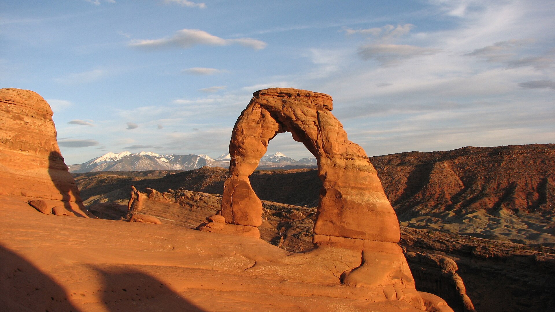
Utah's five national parks are usually attempted as a checklist, which produces a week of car parks. This drops one of them and gives the time to Zion, Bryce and the Moab pair, timed around the sun rather than the map: Zion's canyon early because the shuttle queue is the whole experience otherwise, Bryce's amphitheatre at sunrise when the hoodoos are lit from inside, and Delicate Arch at the end of the day when everyone with a coach has gone. Capitol Reef sits in the middle as the day nobody expects to remember and everybody does.
Day by day
- Day 1
Into Zion
Two and a half hours from Las Vegas, arriving with enough afternoon left for the canyon's easy end.
14:00Zion Canyon Visitor Center and shuttle
The orientation that saves a day: which stops are on which shuttle, and how early tomorrow has to start.
The scenic drive is shuttle-only from spring to late autumn. Private cars are turned around at the junction.
15:30Riverside Walk to the Narrows gate
The gentlest possible introduction to the scale of the place, and the walk everyone else does in the middle of the day.
Paved and flat, three kilometres return. The canyon narrows to twenty metres wide with 600 metres of sandstone above.
19:00Dinner in Springdale
An early night that buys the 6am start tomorrow, which is the single highest-value decision of the week.
Most kitchens in town stop at nine and the good ones fill from six.
- Day 2
Zion, high and wet
The exposed ridge in the morning and the river in the afternoon, which is the right order for both heat and crowds.
06:30Angels Landing
Eight kilometres and 450 metres of climb to a fin with a 300-metre drop on both sides. Scout Lookout alone is still one of the great views in the American West.
A permit is required for the chain section and is issued by lottery. Without one, Scout Lookout is the same walk minus the final half-mile.
13:00The Narrows, bottom-up
Wall Street is two hours upstream and the canyon closes to nine metres wide with the river filling all of it.
You walk in the river. Rent neoprene and a stick in Springdale, and check the flash-flood forecast at the visitor center that morning, every time.
- Day 3
Over the Mount Carmel highway to Bryce
One of the great mountain roads, then an amphitheatre that only works at either end of the day.
08:00Zion-Mount Carmel Highway and the Canyon Overlook
A one-kilometre walk onto a ledge above the switchbacks, which is the canyon seen from outside itself.
The 1930 tunnel has a size limit and oversized vehicles need an escort. Parking at the trailhead is tiny.
18:30Bryce Point at sunset
The widest view of the amphitheatre, and the one where the last light reaches down between the hoodoos rather than across them.
Bryce sits at 2,400 metres and is fifteen degrees colder than Zion. Bring a jacket in any month.
- Day 4
Down among the hoodoos
Bryce from underneath at dawn, then east across the Grand Staircase to Torrey.
06:45Navajo Loop and Queen's Garden
The only way to understand a hoodoo is to stand at the bottom of one, and the switchbacks into Wall Street are the reason people come.
Five kilometres, 180 metres down and back up. Wall Street closes in winter and after heavy rain.
11:30Scenic Byway 12 over Boulder Mountain
One of the most spectacular paved roads in the United States, climbing from slickrock desert to 2,900 metres of aspen in ninety minutes.
The Hogback between Escalante and Boulder is a knife-edge with drops on both sides and no shoulder. Fuel in Escalante.
- Day 5
Capitol Reef
The park nobody plans around, and a hundred-mile wrinkle in the earth's crust.
08:30Capitol Gorge and the Pioneer Register
This slot was the road through the reef until 1962, and settlers carved their names into the wall as they passed.
The last three kilometres of the scenic drive are unpaved and close in rain. Flat walking once you are in the gorge.
12:00Fruita orchards and the Gifford House
A Mormon settlement of a dozen families, still an irrigated green strip in the middle of red rock, with the orchards maintained by the Park Service.
The pies sell out by early afternoon. Fruit picking depends entirely on the season.
18:00Panorama Point and the Goosenecks
Sulphur Creek 250 metres below in a set of tight meanders, and the whole Waterpocket Fold visible along the horizon.
Both viewpoints are a few minutes off Highway 24 with almost no walking.
- Day 6
Canyonlands
Two and a half hours east to Moab, then the mesa top with the Colorado and the Green on either side.
14:00Dead Horse Point
600 metres above a gooseneck of the Colorado, on a mesa joined to the rest of the world by a thirty-metre neck.
A state park, so the national park pass does not cover it.
16:30Mesa Arch and Grand View Point
An arch sitting on the cliff edge with 150 metres of nothing under it, and Grand View Point looking down on two river canyons at once.
Mesa Arch is famous at sunrise and mobbed for it. Late afternoon is quiet and the arch still frames the same country.
- Day 7
Arches, and out
Early into Arches for the walk that defines the state, then the four-hour run north to Salt Lake City.
06:30Delicate Arch
A sixteen-metre freestanding arch on the lip of a natural bowl, with the La Sal Mountains behind it. It is on the state licence plate for a reason.
Arches uses timed-entry reservations in the busy months; book the first slot. Five kilometres return, mostly across open slickrock with no shade.
09:30Windows Section and Double Arch
Three enormous arches within a few hundred metres, and Double Arch is the largest span in the park.
The shortest walking in the park for the most arches per minute, which is what you want on a departure day.
Questions
- How long is the Utah Canyon Country itinerary?
- The Utah Canyon Country itinerary runs 7 days and covers 16 stops across Springdale, Bryce Canyon City, Torrey, Moab.
- When is the best time to do the Utah Canyon Country itinerary?
- Apr, May, Sep, Oct is the best window for the Utah Canyon Country itinerary.
- What happens on day one of the Utah Canyon Country itinerary?
- Day one is into zion: Two and a half hours from Las Vegas, arriving with enough afternoon left for the canyon's easy end.
Sources
Save this itinerary to CarryOn and it becomes a real trip — every stop on your timeline, with entry requirements checked against your passport and the whole thing editable.
Save this as a tripCurated by CarryOn